Visualizing Trees as a Public Health Solution
Mapping Tree Canopy
A growing body of research demonstrates positive connections between human health and access to nature. Being near trees, or even simply having a view of trees, has a host of physical and mental health benefits.
But tree canopy and its benefits are not equally distributed through developed areas. If you examine the satellite view of a neighborhood map, you can visually catalog the houses, streets, and other “gray” infrastructure in contrast to the surrounding trees and “greenspace”. You may notice some areas are dense with green cover, while others appear notably sparse. Urban forestry specialists use geospatial analysis to identify the residential and public spaces that most need more “green”.
Through application of GIS, researchers calculate urban tree canopy (UTC)– essentially, the amount of cover from tree leaves, branches and stems that you see as green on the map. They can even model future changes to UTC based on predictions of urban expansion and management plans. The UTC tool from Texas A&M Forest Service, for example, provides users with maps of UTC in localities across Texas.
Community Applications
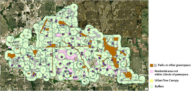
A research project conducted by Texas A&M Forest Service demonstrates the significance of these tools when paired with key health, natural, and social science research. Students and GIS specialists applied UTC data to map the spatial distribution of tree canopy in relation to residential neighborhoods, parks and greenspace, schools, and healthcare facilities throughout Texas.
Practically speaking, projects like this can help communities prioritize on-the-ground applications of data, such as tree plantings and greenspace installations. Ideally, the data can inform decisions that will transform the landscape – optimizing public health and creating equitable environmental access.
Planners might decide to target vacant lots for conversion to pocket parks, increasing the greenspace in a neighborhood. Projects on the landscape scale may include establishing connections between existing blocks of tree canopy to create green corridors – “emerald necklaces” that weave throughout a city, providing accessibility to nature without socioeconomic limitations.
Though their green colors undoubtedly bejewel our maps, we know trees do a lot more than look beautiful – though that’s important, too! With their many environmental, aesthetic, and economic benefits, trees are key to healthy communities. Geospatial analyses of tree canopy can help communities visualize trees as a public health solution in real-time and ultimately encourage investment in urban trees.